Urraween night lights from space
Night Light of Urraween (Queensland) from space (Australia) Src. Average luminocity for 10x10km area is 31.6746% and for 50x50km: 2.4679%.
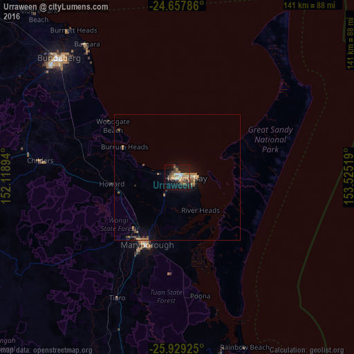
Analysis of Urraween night lights 2016
Square area 10x10 km:
 2.18%
2.18%90-99
3.77%80-89
4.37%70-79
3.97%60-69
6.75%50-59
6.94%40-49
4.76%30-39
4.56%20-29
4.37%10-19
35.52%0-9
22.82%Square area 50x50 km:
0.09%90-99
0.15%80-89
0.26%70-79
0.37%60-69
0.63%50-59
0.51%40-49
0.37%30-39
0.44%20-29
0.26%10-19
2.26%0-9
94.67%Clear (daylight) street map image can be seen on geolist.org.
Map coordinates:
24° 39' 28.3" South, 152° 7' 8.2" East
25° 17' 42.8" South, 152° 49' 19.4" East
25° 55' 45.3" South, 153° 31' 30.7" East
Some cities around Urraween sort by population:
• Bundaberg
67.5 km =41.9 mi,  314°
314°
• Hervey Bay
5.4 km =3.4 mi,  279°
279°
• Maryborough
29.7 km =18.5 mi,  203°
203°
• Urangan
8.4 km =5.2 mi,  87°
87°
• Bargara
64.5 km =40.1 mi,  325°
325°
• Torquay
5.8 km =3.6 mi,  78°
78°
• Point Vernon
4.2 km =2.6 mi,  353°
353°
• Tinana
32.6 km =20.3 mi,  208°
208°
2145361 (p: 7,000)
Sources (retrieved 2019-11-25):
» Earth at Night: Flat Maps 2012, 2016