Runcorn night lights from space
Night Light of Runcorn (Queensland) from space (Australia) Src. Average luminocity for 10x10km area is 85.5099% and for 50x50km: 42.7629%.
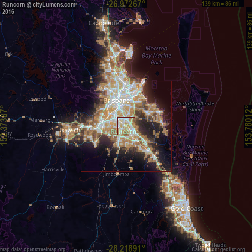
Analysis of Runcorn night lights 2016
Square area 10x10 km:
 20.44%
90-99
26.19%80-89
19.64%70-79
21.23%60-69
7.54%50-59
3.97%40-49
0.99%30-39
0%20-29
0%10-19
0%0-9
0%Square area 50x50 km:
8.17%90-99
8.99%80-89
5.14%70-79
5.84%60-69
11.46%50-59
3.7%40-49
4.13%30-39
4.61%20-29
7.35%10-19
12.62%0-9
27.98%Clear (daylight) street map image can be seen on geolist.org.
Map coordinates:
26° 58' 21.6" South, 152° 22' 25.9" East
27° 35' 51.2" South, 153° 4' 37.2" East
28° 13' 8.1" South, 153° 46' 48.4" East
Some cities around Runcorn sort by population:
• Sunnybank Hills
2.7 km =1.7 mi,  238°
238°
• Calamvale
4.1 km =2.5 mi,  225°
225°
• Eight Mile Plains
2.8 km =1.7 mi,  55°
55°
• Upper Mount Gravatt
4.1 km =2.5 mi,  10°
10°
• Sunnybank
2.5 km =1.6 mi,  320°
320°
• Kuraby
1.9 km =1.2 mi,  122°
122°
• Underwood
3.6 km =2.2 mi,  110°
110°
• Macgregor
3.8 km =2.4 mi,  344°
344°
8348933 (p: 14,434)
Sources (retrieved 2019-11-25):
» Earth at Night: Flat Maps 2012, 2016