Tweed Heads night lights from space
Night Light of Tweed Heads (New South Wales) from space (Australia) Src. Average luminocity for 10x10km area is 31.0739% and for 50x50km: 11.2442%.
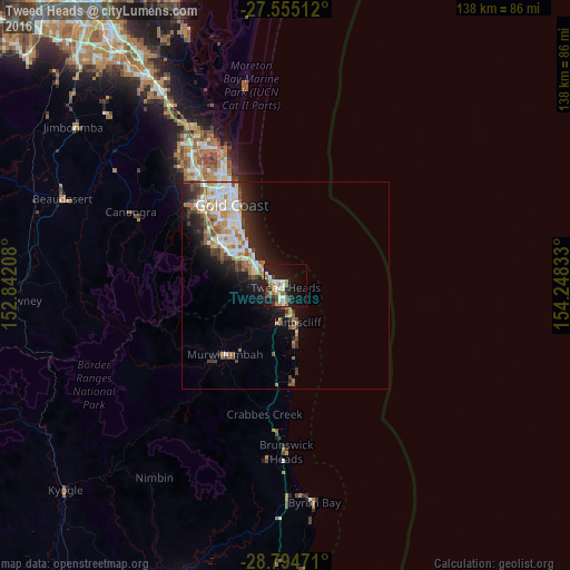
Analysis of Tweed Heads night lights 2016
Square area 10x10 km:
 5.3%
5.3%90-99
6.06%80-89
2.27%70-79
0.95%60-69
8.33%50-59
3.6%40-49
2.08%30-39
2.65%20-29
10.04%10-19
31.06%0-9
27.65%Square area 50x50 km:
2.25%90-99
2.22%80-89
0.94%70-79
0.84%60-69
2.55%50-59
1.15%40-49
1.23%30-39
1.56%20-29
3.03%10-19
6%0-9
78.23%Clear (daylight) street map image can be seen on geolist.org.
Map coordinates:
27° 33' 18.4" South, 152° 50' 31.5" East
28° 10' 36.2" South, 153° 32' 42.7" East
28° 47' 41" South, 154° 14' 54" East
Some cities around Tweed Heads sort by population:
• Banora Point
4.1 km =2.5 mi,  192°
192°
• Palm Beach
10.2 km =6.3 mi,  310°
310°
• Elanora
10.4 km =6.5 mi,  295°
295°
• Burleigh Heads
12.6 km =7.8 mi, 312°
• Currumbin Waters
7.5 km =4.7 mi,  289°
289°
• Coolangatta
1.3 km =0.8 mi, 308°
• Kingscliff
9.8 km =6.1 mi,  160°
160°
• Tugun
5.3 km =3.3 mi, 303°
2145765 (p: 9,017)
Sources (retrieved 2019-11-25):
» Earth at Night: Flat Maps 2012, 2016