Templestowe night lights from space
Night Light of Templestowe (Victoria) from space (Australia) Src. Average luminocity for 10x10km area is 53.4218% and for 50x50km: 44.702%.
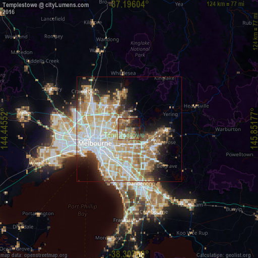
Analysis of Templestowe night lights 2016
Square area 10x10 km:
 1.7%
1.7%90-99
7.99%80-89
5.44%70-79
9.52%60-69
16.33%50-59
18.88%40-49
12.41%30-39
6.12%20-29
10.03%10-19
10.03%0-9
1.53%Square area 50x50 km:
11.32%90-99
10.31%80-89
5.71%70-79
8.3%60-69
6.89%50-59
4.78%40-49
3.52%30-39
3.02%20-29
4.8%10-19
7.5%0-9
33.86%Clear (daylight) street map image can be seen on geolist.org.
Map coordinates:
37° 11' 45.7" South, 144° 26' 43.9" East
37° 45' 14.6" South, 145° 8' 55.1" East
38° 18' 28.4" South, 145° 51' 6.4" East
Some cities around Templestowe sort by population:
• Doncaster East
3.7 km =2.3 mi,  179°
179°
• Doncaster
4.4 km =2.7 mi,  209°
209°
• Eltham
2.3 km =1.4 mi,  2°
2°
• Donvale
4.5 km =2.8 mi,  149°
149°
• Box Hill North
5.7 km =3.5 mi,  199°
199°
• Bulleen
5.9 km =3.7 mi,  256°
256°
• Montmorency
5 km =3.1 mi,  325°
325°
• Viewbank
5.1 km =3.2 mi,  287°
287°
2147140 (p: 16,305)
Sources (retrieved 2019-11-25):
» Earth at Night: Flat Maps 2012, 2016