Singleton night lights from space
Night Light of Singleton (New South Wales) from space (Australia) Src. Average luminocity for 10x10km area is 16.1031% and for 50x50km: 6.1561%.
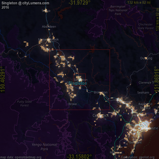
Analysis of Singleton night lights 2016
Square area 10x10 km:
 1.22%
1.22%90-99
0.87%80-89
0%70-79
2.45%60-69
6.99%50-59
2.27%40-49
1.92%30-39
2.45%20-29
0.7%10-19
6.29%0-9
74.83%Square area 50x50 km:
0.27%90-99
0.19%80-89
0.07%70-79
1.06%60-69
2.16%50-59
0.79%40-49
0.98%30-39
1.76%20-29
0.85%10-19
4.29%0-9
87.58%Clear (daylight) street map image can be seen on geolist.org.
Map coordinates:
31° 58' 22.4" South, 150° 27' 46.5" East
32° 34' 2.7" South, 151° 9' 57.7" East
33° 9' 28.9" South, 151° 52' 9" East
Some cities around Singleton sort by population:
• Maitland
41 km =25.5 mi,  116°
116°
• Cessnock
34.4 km =21.4 mi,  148°
148°
• Muswellbrook
42.8 km =26.6 mi,  322°
322°
• Rutherford
38.2 km =23.7 mi, 115°
• East Maitland
44 km =27.3 mi, 117°
• Thornton
49.9 km =31 mi, 118°
• Kurri Kurri
40.5 km =25.2 mi,  133°
133°
• Aberglasslyn
37.4 km =23.2 mi,  113°
113°
2149475 (p: 5,076)
Sources (retrieved 2019-11-25):
» Earth at Night: Flat Maps 2012, 2016