Raceview night lights from space
Night Light of Raceview (Queensland) from space (Australia) Src. Average luminocity for 10x10km area is 61.4881% and for 50x50km: 19.3759%.
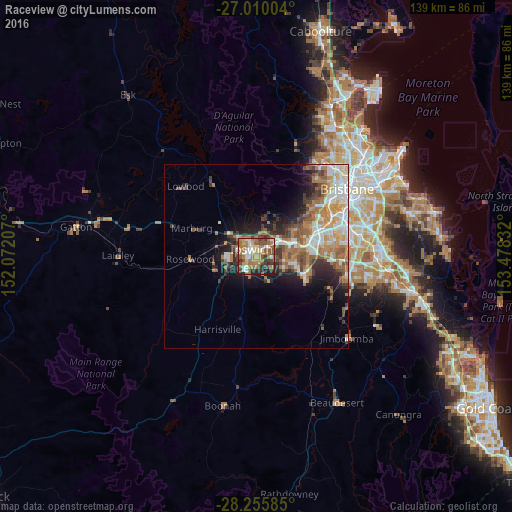
Analysis of Raceview night lights 2016
Square area 10x10 km:
 7.94%
7.94%90-99
9.92%80-89
5.56%70-79
7.14%60-69
29.96%50-59
5.56%40-49
14.68%30-39
6.15%20-29
11.31%10-19
1.79%0-9
0%Square area 50x50 km:
3.3%90-99
3.51%80-89
1.72%70-79
1.96%60-69
5.98%50-59
2.5%40-49
2.66%30-39
2.69%20-29
3.85%10-19
6.55%0-9
65.28%Clear (daylight) street map image can be seen on geolist.org.
Map coordinates:
27° 0' 36.1" South, 152° 4' 19.5" East
27° 38' 5" South, 152° 46' 30.7" East
28° 15' 21.1" South, 153° 28' 42" East
Some cities around Raceview sort by population:
• Redbank Plains
8.4 km =5.2 mi,  98°
98°
• Brassall
5 km =3.1 mi,  326°
326°
• Goodna
12.5 km =7.8 mi,  77°
77°
• Collingwood Park
8.7 km =5.4 mi,  73°
73°
• Bellbird Park
11 km =6.8 mi,  91°
91°
• Bundamba
4.5 km =2.8 mi,  51°
51°
• Flinders View
1.8 km =1.1 mi,  182°
182°
• Bellbowrie
13.5 km =8.4 mi, 51°
7932664 (p: 9,601)
Sources (retrieved 2019-11-25):
» Earth at Night: Flat Maps 2012, 2016