Parkinson night lights from space
Night Light of Parkinson (Queensland) from space (Australia) Src. Average luminocity for 10x10km area is 71.1944% and for 50x50km: 38.5186%.
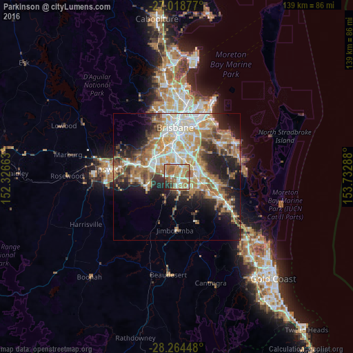
Analysis of Parkinson night lights 2016
Square area 10x10 km:
 11.31%
90-99
14.68%80-89
7.54%70-79
17.06%60-69
23.02%50-59
14.48%40-49
3.77%30-39
1.19%20-29
6.55%10-19
0.4%0-9
0%Square area 50x50 km:
6.96%90-99
7.55%80-89
4.19%70-79
5.27%60-69
11.22%50-59
3.63%40-49
4.27%30-39
4.61%20-29
7.4%10-19
11.38%0-9
33.51%Clear (daylight) street map image can be seen on geolist.org.
Map coordinates:
27° 1' 7.6" South, 152° 19' 35.9" East
27° 38' 36.2" South, 153° 1' 47.1" East
28° 15' 52.1" South, 153° 43' 58.4" East
Some cities around Parkinson sort by population:
• Forest Lake
6.3 km =3.9 mi,  288°
288°
• Sunnybank Hills
4.4 km =2.7 mi,  32°
32°
• Calamvale
2.9 km =1.8 mi,  38°
38°
• Regents Park
3.9 km =2.4 mi,  162°
162°
• Algester
3.4 km =2.1 mi,  4°
4°
• Boronia Heights
5.1 km =3.2 mi,  191°
191°
• Acacia Ridge
6.7 km =4.2 mi, 3°
• Hillcrest
2.8 km =1.7 mi, 187°
8349037 (p: 10,708)
Sources (retrieved 2019-11-25):
» Earth at Night: Flat Maps 2012, 2016