Warriewood night lights from space
Night Light of Warriewood (New South Wales) from space (Australia) Src. Average luminocity for 10x10km area is 32.0073% and for 50x50km: 22.4029%.
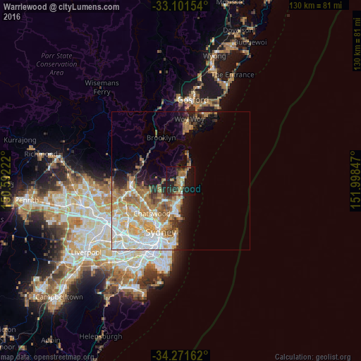
Analysis of Warriewood night lights 2016
Square area 10x10 km:
 0.37%
0.37%90-99
3.3%80-89
1.47%70-79
4.4%60-69
14.1%50-59
4.76%40-49
0.73%30-39
9.16%20-29
13.19%10-19
33.52%0-9
15.02%Square area 50x50 km:
4.48%90-99
4.8%80-89
2.53%70-79
3.99%60-69
5.34%50-59
2.15%40-49
1.42%30-39
2.26%20-29
2.94%10-19
5.95%0-9
64.13%Clear (daylight) street map image can be seen on geolist.org.
Map coordinates:
33° 6' 5.5" South, 150° 35' 32" East
33° 41' 18.9" South, 151° 17' 43.2" East
34° 16' 17.8" South, 151° 59' 54.5" East
Some cities around Warriewood sort by population:
• Dee Why
7 km =4.3 mi,  184°
184°
• Mona Vale
1.4 km =0.9 mi,  30°
30°
• Newport
4 km =2.5 mi, 25°
• Narrabeen
2.7 km =1.7 mi, 176°
• Collaroy
4.9 km =3 mi,  173°
173°
• Cromer
5.4 km =3.4 mi,  208°
208°
• Narraweena
7.6 km =4.7 mi,  193°
193°
• North Narrabeen
2.3 km =1.4 mi, 178°
8347932 (p: 7,265)
Sources (retrieved 2019-11-25):
» Earth at Night: Flat Maps 2012, 2016