Mountain Creek night lights from space
Night Light of Mountain Creek (Queensland) from space (Australia) Src. Average luminocity for 10x10km area is 53.6231% and for 50x50km: 8.6947%.
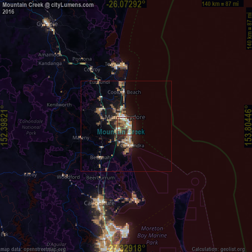
Analysis of Mountain Creek night lights 2016
Square area 10x10 km:
 7.39%
7.39%90-99
9.47%80-89
5.49%70-79
4.36%60-69
21.4%50-59
5.68%40-49
9.28%30-39
5.11%20-29
18.37%10-19
13.26%0-9
0.19%Square area 50x50 km:
0.65%90-99
0.9%80-89
0.53%70-79
0.51%60-69
3.5%50-59
1.22%40-49
1.51%30-39
1.3%20-29
2.31%10-19
6.5%0-9
81.07%Clear (daylight) street map image can be seen on geolist.org.
Map coordinates:
26° 4' 22.5" South, 152° 23' 53.6" East
26° 42' 10" South, 153° 6' 4.8" East
27° 19' 45" South, 153° 48' 16.1" East
Some cities around Mountain Creek sort by population:
• Buderim
4.8 km =3 mi,  294°
294°
• Maroochydore
4.8 km =3 mi,  357°
357°
• Sippy Downs
4.9 km =3 mi,  249°
249°
• Little Mountain
9.1 km =5.7 mi,  185°
185°
• Mooloolaba
2.9 km =1.8 mi,  37°
37°
• Currimundi
7.7 km =4.8 mi,  164°
164°
• Caloundra West
11.5 km =7.1 mi,  176°
176°
• Wurtulla
6.5 km =4 mi, 156°
8349412 (p: 11,080)
Sources (retrieved 2019-11-25):
» Earth at Night: Flat Maps 2012, 2016