Wurtulla night lights from space
Night Light of Wurtulla (Queensland) from space (Australia) Src. Average luminocity for 10x10km area is 41.4504% and for 50x50km: 8.0791%.
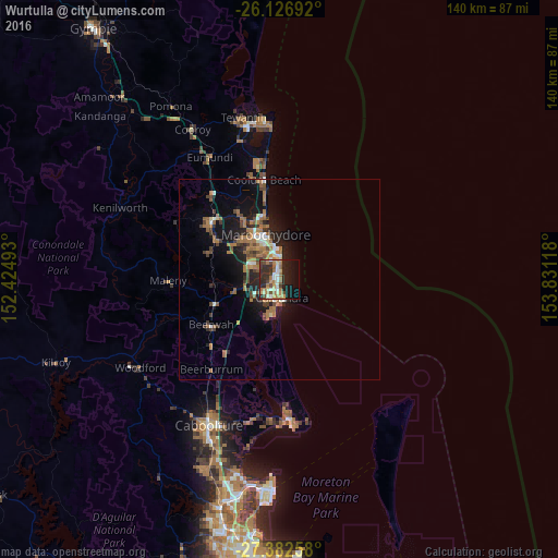
Analysis of Wurtulla night lights 2016
Square area 10x10 km:
 3.77%
3.77%90-99
6.35%80-89
5.56%70-79
4.96%60-69
13.29%50-59
2.78%40-49
6.75%30-39
5.56%20-29
17.86%10-19
20.63%0-9
12.5%Square area 50x50 km:
0.62%90-99
0.88%80-89
0.51%70-79
0.51%60-69
3.19%50-59
1.08%40-49
1.37%30-39
1.13%20-29
2.25%10-19
6.37%0-9
82.1%Clear (daylight) street map image can be seen on geolist.org.
Map coordinates:
26° 7' 36.9" South, 152° 25' 29.7" East
26° 45' 23.3" South, 153° 7' 41" East
27° 22' 57.3" South, 153° 49' 52.2" East
Some cities around Wurtulla sort by population:
• Mountain Creek
6.5 km =4 mi,  336°
336°
• Sippy Downs
8.4 km =5.2 mi,  300°
300°
• Little Mountain
4.7 km =2.9 mi,  228°
228°
• Mooloolaba
8.4 km =5.2 mi,  354°
354°
• Currimundi
1.5 km =0.9 mi,  201°
201°
• Pelican Waters
9 km =5.6 mi, 197°
• Caloundra West
5.9 km =3.7 mi, 198°
• Golden Beach
7.3 km =4.5 mi,  186°
186°
8348974 (p: 5,852)
Sources (retrieved 2019-11-25):
» Earth at Night: Flat Maps 2012, 2016