Currimundi night lights from space
Night Light of Currimundi (Queensland) from space (Australia) Src. Average luminocity for 10x10km area is 42.7004% and for 50x50km: 7.9449%.
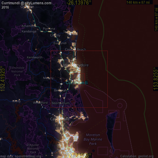
Analysis of Currimundi night lights 2016
Square area 10x10 km:
 4.76%
4.76%90-99
6.94%80-89
4.56%70-79
4.76%60-69
13.89%50-59
3.37%40-49
6.55%30-39
4.56%20-29
20.44%10-19
20.83%0-9
9.33%Square area 50x50 km:
0.61%90-99
0.86%80-89
0.51%70-79
0.51%60-69
3.13%50-59
1.03%40-49
1.36%30-39
1.13%20-29
2.29%10-19
6.32%0-9
82.26%Clear (daylight) street map image can be seen on geolist.org.
Map coordinates:
26° 8' 23.1" South, 152° 25' 9.3" East
26° 46' 9.3" South, 153° 7' 20.5" East
27° 23' 43" South, 153° 49' 31.8" East
Some cities around Currimundi sort by population:
• Mountain Creek
7.7 km =4.8 mi,  344°
344°
• Sippy Downs
8.8 km =5.5 mi,  310°
310°
• Little Mountain
3.4 km =2.1 mi,  240°
240°
• Mooloolaba
9.7 km =6 mi,  358°
358°
• Pelican Waters
7.5 km =4.7 mi,  197°
197°
• Caloundra West
4.3 km =2.7 mi, 197°
• Golden Beach
5.8 km =3.6 mi,  182°
182°
• Wurtulla
1.5 km =0.9 mi,  21°
21°
8349370 (p: 6,565)
Sources (retrieved 2019-11-25):
» Earth at Night: Flat Maps 2012, 2016