Mittagong night lights from space
Night Light of Mittagong (New South Wales) from space (Australia) Src. Average luminocity for 10x10km area is 13.6958% and for 50x50km: 1.349%.
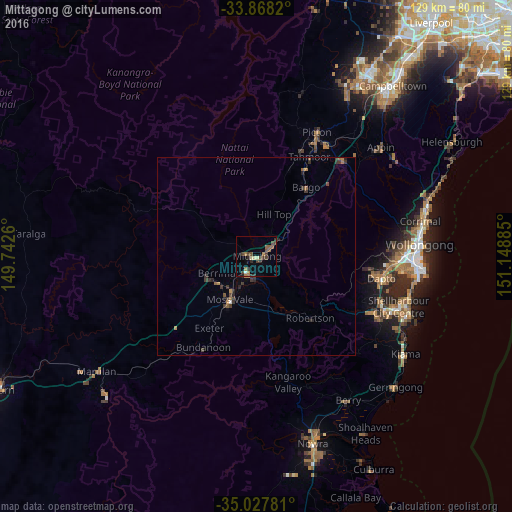
Analysis of Mittagong night lights 2016
Square area 10x10 km:
 0.17%
0.17%90-99
1.05%80-89
1.57%70-79
0.52%60-69
2.97%50-59
4.2%40-49
3.32%30-39
4.9%20-29
2.27%10-19
0.52%0-9
78.5%Square area 50x50 km:
0.02%90-99
0.06%80-89
0.06%70-79
0.11%60-69
0.32%50-59
0.32%40-49
0.27%30-39
0.69%20-29
0.41%10-19
0.08%0-9
97.65%Clear (daylight) street map image can be seen on geolist.org.
Map coordinates:
33° 52' 5.5" South, 149° 44' 33.4" East
34° 27' 0.1" South, 150° 26' 44.6" East
35° 1' 40.1" South, 151° 8' 55.9" East
Some cities around Mittagong sort by population:
• Albion Park
33.1 km =20.6 mi,  114°
114°
• Dapto
32.5 km =20.2 mi,  100°
100°
• Bowral
3.8 km =2.4 mi,  217°
217°
• Moss Vale
13.4 km =8.3 mi,  210°
210°
• Horsley
30.7 km =19.1 mi, 97°
• Albion Park Rail
34.2 km =21.3 mi, 112°
• Kanahooka
33.5 km =20.8 mi, 97°
• Tahmoor
28.8 km =17.9 mi,  28°
28°
2157373 (p: 5,725)
Sources (retrieved 2019-11-25):
» Earth at Night: Flat Maps 2012, 2016