Moss Vale night lights from space
Night Light of Moss Vale (New South Wales) from space (Australia) Src. Average luminocity for 10x10km area is 8.3287% and for 50x50km: 1.0915%.
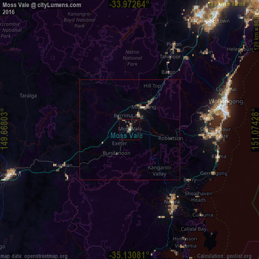
Analysis of Moss Vale night lights 2016
Square area 10x10 km:
 0.35%
0.35%90-99
0.35%80-89
0%70-79
1.4%60-69
1.4%50-59
1.92%40-49
1.4%30-39
5.07%20-29
2.45%10-19
0.7%0-9
84.97%Square area 50x50 km:
0.02%90-99
0.06%80-89
0.06%70-79
0.09%60-69
0.22%50-59
0.25%40-49
0.22%30-39
0.55%20-29
0.34%10-19
0.07%0-9
98.13%Clear (daylight) street map image can be seen on geolist.org.
Map coordinates:
33° 58' 21.5" South, 149° 40' 4.9" East
34° 33' 13.5" South, 150° 22' 16.1" East
35° 7' 50.9" South, 151° 4' 27.4" East
Some cities around Moss Vale sort by population:
• Albion Park
37.1 km =23.1 mi,  93°
93°
• Dapto
39.1 km =24.3 mi,  81°
81°
• Bowral
9.6 km =6 mi,  28°
28°
• Horsley
38 km =23.6 mi, 78°
• Albion Park Rail
38.5 km =23.9 mi, 92°
• Bomaderry
39.5 km =24.5 mi,  146°
146°
• Mittagong
13.4 km =8.3 mi, 30°
• North Nowra
38.6 km =24 mi, 151°
2156777 (p: 8,430)
Sources (retrieved 2019-11-25):
» Earth at Night: Flat Maps 2012, 2016