Howard Springs night lights from space
Night Light of Howard Springs (Northern Territory) from space (Australia) Src. Average luminocity for 10x10km area is 23.803% and for 50x50km: 9.8799%.
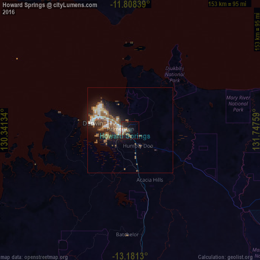
Analysis of Howard Springs night lights 2016
Square area 10x10 km:
 3.25%
3.25%90-99
2.38%80-89
1.3%70-79
0.22%60-69
4.98%50-59
8.23%40-49
2.16%30-39
4.76%20-29
9.31%10-19
20.78%0-9
42.64%Square area 50x50 km:
1.33%90-99
1.51%80-89
1.01%70-79
0.54%60-69
2.31%50-59
2.63%40-49
0.87%30-39
1.49%20-29
3.2%10-19
5.51%0-9
79.6%Clear (daylight) street map image can be seen on geolist.org.
Map coordinates:
11° 48' 30.2" South, 130° 20' 28.8" East
12° 29' 44.7" South, 131° 2' 40.1" East
13° 10' 52.7" South, 131° 44' 51.3" East
Some cities around Howard Springs sort by population:
• Darwin
22.3 km =13.9 mi,  279°
279°
• Palmerston
6.7 km =4.2 mi, 279°
• Lospalos, TL
625.2 km =388.5 mi,  314°
314°
• Baukau, TL
671.8 km =417.4 mi, 311°
• Venilale, TL
666 km =413.8 mi, 310°
• Same, TL
705.7 km =438.5 mi,  303°
303°
• Kununurra
441.4 km =274.3 mi,  214°
214°
• Viqueque, TL
651.9 km =405.1 mi, 308°
8310720 (p: 6,852)
Sources (retrieved 2019-11-25):
» Earth at Night: Flat Maps 2012, 2016