Doubleview night lights from space
Night Light of Doubleview (Western Australia) from space (Australia) Src. Average luminocity for 10x10km area is 76.8498% and for 50x50km: 39.4052%.
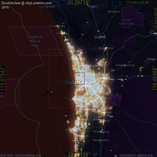
Analysis of Doubleview night lights 2016
Square area 10x10 km:
 25.46%
90-99
26.92%80-89
7.88%70-79
9.52%60-69
8.06%50-59
2.38%40-49
0.73%30-39
3.11%20-29
13.19%10-19
2.75%0-9
0%Square area 50x50 km:
9.31%90-99
10.18%80-89
4.69%70-79
6.47%60-69
6.93%50-59
3.83%40-49
2.69%30-39
2.83%20-29
5.66%10-19
6.32%0-9
41.08%Clear (daylight) street map image can be seen on geolist.org.
Map coordinates:
31° 17' 50.6" South, 115° 4' 42.3" East
31° 53' 46.6" South, 115° 46' 53.6" East
32° 29' 28.6" South, 116° 29' 4.8" East
Some cities around Doubleview sort by population:
• Scarborough
1.6 km =1 mi,  271°
271°
• Stirling
3 km =1.9 mi,  61°
61°
• Karrinyup
2.7 km =1.7 mi,  350°
350°
• Innaloo
1.3 km =0.8 mi,  72°
72°
• Floreat
4.8 km =3 mi,  168°
168°
• City Beach
4.6 km =2.9 mi,  203°
203°
• Carine
4.9 km =3 mi,  1°
1°
• Wembley Downs
1.9 km =1.2 mi, 203°
8348415 (p: 8,160)
Sources (retrieved 2019-11-25):
» Earth at Night: Flat Maps 2012, 2016