Flagstaff Hill night lights from space
Night Light of Flagstaff Hill (South Australia) from space (Australia) Src. Average luminocity for 10x10km area is 55.4248% and for 50x50km: 20.8385%.
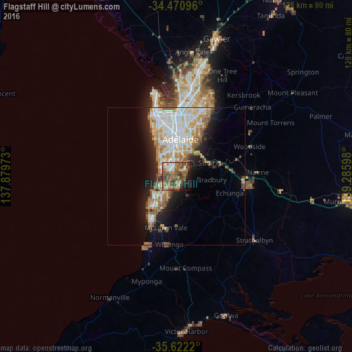
Analysis of Flagstaff Hill night lights 2016
Square area 10x10 km:
 6.64%
6.64%90-99
5.59%80-89
1.4%70-79
8.22%60-69
17.13%50-59
22.9%40-49
18.01%30-39
6.64%20-29
2.27%10-19
9.62%0-9
1.57%Square area 50x50 km:
4.63%90-99
4.52%80-89
1.99%70-79
3.48%60-69
3.41%50-59
2.7%40-49
2.09%30-39
1.4%20-29
3.4%10-19
7.25%0-9
65.14%Clear (daylight) street map image can be seen on geolist.org.
Map coordinates:
34° 28' 15.5" South, 137° 52' 47" East
35° 2' 55" South, 138° 34' 58.3" East
35° 37' 19.9" South, 139° 17' 9.5" East
Some cities around Flagstaff Hill sort by population:
• Hallett Cove
7.1 km =4.4 mi,  241°
241°
• Happy Valley
5.9 km =3.7 mi,  229°
229°
• Woodcroft
6.2 km =3.9 mi,  196°
196°
• Aberfoyle Park
3.2 km =2 mi,  165°
165°
• Sheidow Park
6.1 km =3.8 mi, 235°
• Mitchell Park
4.6 km =2.9 mi,  336°
336°
• Somerton Park
8 km =5 mi,  315°
315°
• Warradale
7.4 km =4.6 mi, 320°
8348986 (p: 9,624)
Sources (retrieved 2019-11-25):
» Earth at Night: Flat Maps 2012, 2016