Chadstone night lights from space
Night Light of Chadstone (Victoria) from space (Australia) Src. Average luminocity for 10x10km area is 88.7825% and for 50x50km: 52.6373%.
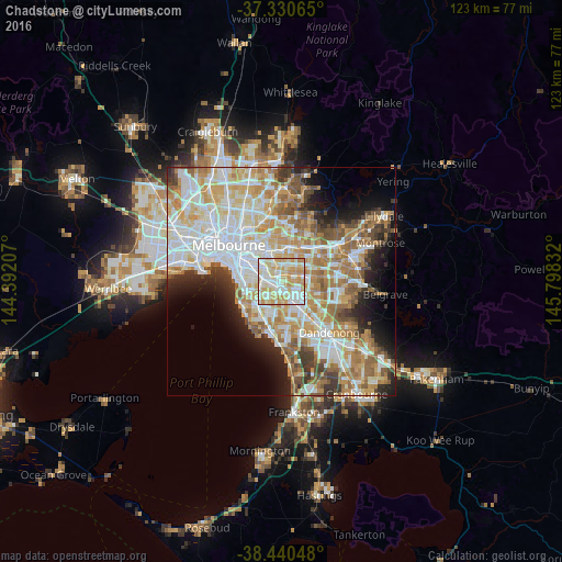
Analysis of Chadstone night lights 2016
Square area 10x10 km:
 24.84%
90-99
28.9%80-89
20.29%70-79
21.59%60-69
4.38%50-59
0%40-49
0%30-39
0%20-29
0%10-19
0%0-9
0%Square area 50x50 km:
13.64%90-99
12.78%80-89
6.61%70-79
9.27%60-69
8.04%50-59
5.98%40-49
4.04%30-39
3.73%20-29
5.04%10-19
6.97%0-9
23.9%Clear (daylight) street map image can be seen on geolist.org.
Map coordinates:
37° 19' 50.3" South, 144° 23' 31.5" East
37° 53' 15.6" South, 145° 5' 42.7" East
38° 26' 25.7" South, 145° 47' 54" East
Some cities around Chadstone sort by population:
• Mount Waverley
3.2 km =2 mi,  68°
68°
• Glen Iris
3.4 km =2.1 mi,  312°
312°
• Murrumbeena
2.9 km =1.8 mi,  241°
241°
• Oakleigh
1.3 km =0.8 mi,  207°
207°
• Ashburton
2.6 km =1.6 mi,  335°
335°
• Hughesdale
1.7 km =1.1 mi,  217°
217°
• Ashwood
2.5 km =1.6 mi,  21°
21°
• Oakleigh East
2.3 km =1.4 mi,  126°
126°
7932635 (p: 8,579)
Sources (retrieved 2019-11-25):
» Earth at Night: Flat Maps 2012, 2016