Oakleigh night lights from space
Night Light of Oakleigh (Victoria) from space (Australia) Src. Average luminocity for 10x10km area is 89.7321% and for 50x50km: 52.6895%.
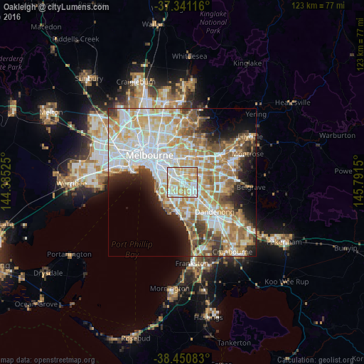
Analysis of Oakleigh night lights 2016
Square area 10x10 km:
 26.62%
90-99
30.36%80-89
19.48%70-79
21.1%60-69
2.44%50-59
0%40-49
0%30-39
0%20-29
0%10-19
0%0-9
0%Square area 50x50 km:
13.76%90-99
12.83%80-89
6.7%70-79
9.31%60-69
7.84%50-59
5.99%40-49
3.96%30-39
3.64%20-29
4.99%10-19
6.88%0-9
24.11%Clear (daylight) street map image can be seen on geolist.org.
Map coordinates:
37° 20' 28.2" South, 144° 23' 6.9" East
37° 53' 53.1" South, 145° 5' 18.1" East
38° 27' 3" South, 145° 47' 29.4" East
Some cities around Oakleigh sort by population:
• Bentleigh East
3.9 km =2.4 mi,  232°
232°
• Clayton
3.2 km =2 mi,  129°
129°
• Carnegie
2.9 km =1.8 mi,  279°
279°
• Murrumbeena
1.9 km =1.2 mi,  263°
263°
• Chadstone
1.3 km =0.8 mi,  27°
27°
• Ashburton
3.5 km =2.2 mi,  352°
352°
• Hughesdale
0.5 km =0.3 mi,  244°
244°
• Ashwood
3.8 km =2.4 mi,  23°
23°
2154618 (p: 7,822)
Sources (retrieved 2019-11-25):
» Earth at Night: Flat Maps 2012, 2016