Belmont North night lights from space
Night Light of Belmont North (New South Wales) from space (Australia) Src. Average luminocity for 10x10km area is 32.7271% and for 50x50km: 13.4358%.
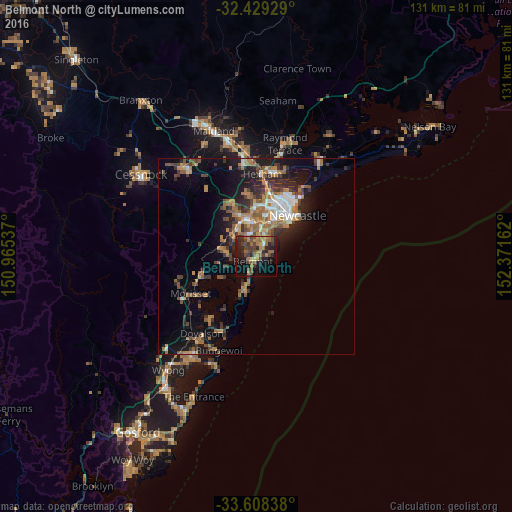
Analysis of Belmont North night lights 2016
Square area 10x10 km:
 0.37%
0.37%90-99
0.37%80-89
2.56%70-79
4.58%60-69
13.55%50-59
5.31%40-49
9.34%30-39
9.16%20-29
12.45%10-19
27.29%0-9
15.02%Square area 50x50 km:
1.31%90-99
1.47%80-89
0.57%70-79
2.15%60-69
3.66%50-59
2.08%40-49
2.01%30-39
3.03%20-29
3.72%10-19
8.23%0-9
71.77%Clear (daylight) street map image can be seen on geolist.org.
Map coordinates:
32° 25' 45.4" South, 150° 57' 55.3" East
33° 1' 14.9" South, 151° 40' 6.6" East
33° 36' 30.2" South, 152° 22' 17.8" East
Some cities around Belmont North sort by population:
• Charlestown
6.3 km =3.9 mi,  21°
21°
• Merewether
10.7 km =6.6 mi,  40°
40°
• Warners Bay
5.6 km =3.5 mi,  344°
344°
• Adamstown
10.6 km =6.6 mi,  30°
30°
• Toronto
7 km =4.3 mi,  276°
276°
• Eleebana
4.6 km =2.9 mi,  319°
319°
• Valentine
2.5 km =1.6 mi,  285°
285°
• Adamstown Heights
8.9 km =5.5 mi, 25°
10103878 (p: 6,168)
Sources (retrieved 2019-11-25):
» Earth at Night: Flat Maps 2012, 2016