Valentine night lights from space
Night Light of Valentine (New South Wales) from space (Australia) Src. Average luminocity for 10x10km area is 34.1136% and for 50x50km: 13.5947%.
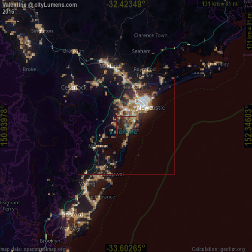
Analysis of Valentine night lights 2016
Square area 10x10 km:
 0.37%
0.37%90-99
0.37%80-89
2.75%70-79
6.04%60-69
13.19%50-59
4.4%40-49
8.79%30-39
12.09%20-29
12.09%10-19
29.3%0-9
10.62%Square area 50x50 km:
1.32%90-99
1.47%80-89
0.57%70-79
2.12%60-69
3.69%50-59
2.1%40-49
2.04%30-39
3.07%20-29
3.75%10-19
8.45%0-9
71.41%Clear (daylight) street map image can be seen on geolist.org.
Map coordinates:
32° 25' 24.6" South, 150° 56' 23.2" East
33° 0' 54.1" South, 151° 38' 34.4" East
33° 36' 9.5" South, 152° 20' 45.7" East
Some cities around Valentine sort by population:
• Charlestown
7 km =4.3 mi,  42°
42°
• Warners Bay
4.8 km =3 mi,  10°
10°
• Belmont
2.1 km =1.3 mi,  130°
130°
• Belmont North
2.5 km =1.6 mi,  105°
105°
• Edgeworth
10.3 km =6.4 mi,  345°
345°
• Toronto
4.6 km =2.9 mi,  272°
272°
• Eleebana
2.9 km =1.8 mi, 347°
• Adamstown Heights
9.6 km =6 mi, 40°
8349225 (p: 5,417)
Sources (retrieved 2019-11-25):
» Earth at Night: Flat Maps 2012, 2016