Beerwah night lights from space
Night Light of Beerwah (Queensland) from space (Australia) Src. Average luminocity for 10x10km area is 5.4107% and for 50x50km: 8.4207%.
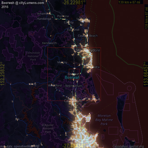
Analysis of Beerwah night lights 2016
Square area 10x10 km:
 0.6%
0.6%90-99
0.2%80-89
0%70-79
0.4%60-69
0.79%50-59
0.79%40-49
0.79%30-39
3.97%20-29
0.99%10-19
0.99%0-9
90.48%Square area 50x50 km:
0.63%90-99
0.87%80-89
0.54%70-79
0.55%60-69
3.33%50-59
1.13%40-49
1.4%30-39
1.61%20-29
2.47%10-19
5.88%0-9
81.58%Clear (daylight) street map image can be seen on geolist.org.
Map coordinates:
26° 13' 47.3" South, 152° 15' 30" East
26° 51' 31.7" South, 152° 57' 41.2" East
27° 29' 3.6" South, 153° 39' 52.5" East
Some cities around Beerwah sort by population:
• Sippy Downs
18.2 km =11.3 mi,  30°
30°
• Little Mountain
15.4 km =9.6 mi,  57°
57°
• Currimundi
18.8 km =11.7 mi, 58°
• Pelican Waters
14 km =8.7 mi,  78°
78°
• Caloundra West
15.8 km =9.8 mi,  68°
68°
• Golden Beach
16.2 km =10.1 mi, 75°
• Wurtulla
20.1 km =12.5 mi, 55°
• Palmwoods
19.2 km =11.9 mi,  359°
359°
2176406 (p: 6,711)
Sources (retrieved 2019-11-25):
» Earth at Night: Flat Maps 2012, 2016