Bassendean night lights from space
Night Light of Bassendean (Western Australia) from space (Australia) Src. Average luminocity for 10x10km area is 85.8427% and for 50x50km: 41.4954%.
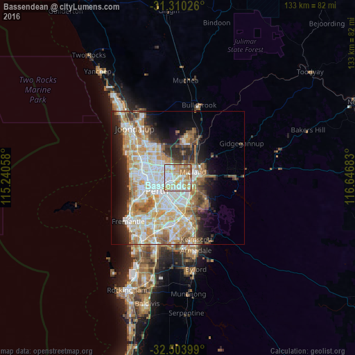
Analysis of Bassendean night lights 2016
Square area 10x10 km:
 25.7%
25.7%90-99
26.57%80-89
10.84%70-79
18.18%60-69
15.03%50-59
3.5%40-49
0.17%30-39
0%20-29
0%10-19
0%0-9
0%Square area 50x50 km:
9.44%90-99
10.41%80-89
4.82%70-79
6.65%60-69
7.48%50-59
4.41%40-49
2.93%30-39
3.37%20-29
6.05%10-19
8.15%0-9
36.29%Clear (daylight) street map image can be seen on geolist.org.
Map coordinates:
31° 18' 36.9" South, 115° 14' 26.1" East
31° 54' 32.6" South, 115° 56' 37.3" East
32° 30' 14.4" South, 116° 38' 48.6" East
Some cities around Bassendean sort by population:
• Morley
4 km =2.5 mi,  306°
306°
• Bayswater
2.6 km =1.6 mi,  250°
250°
• Maylands
5.2 km =3.2 mi,  242°
242°
• Beechboro
4.9 km =3 mi,  352°
352°
• Belmont
4.2 km =2.6 mi,  204°
204°
• Bedford
5.2 km =3.2 mi,  267°
267°
• Bennett Springs
5.5 km =3.4 mi,  1°
1°
• Caversham
3.6 km =2.2 mi,  37°
37°
2077030 (p: 10,141)
Sources (retrieved 2019-11-25):
» Earth at Night: Flat Maps 2012, 2016