Leibnitz night lights from space
Night Light of Leibnitz (Styria) from space (Austria) Src. Average luminocity for 10x10km area is 9.7545% and for 50x50km: 4.2973%.
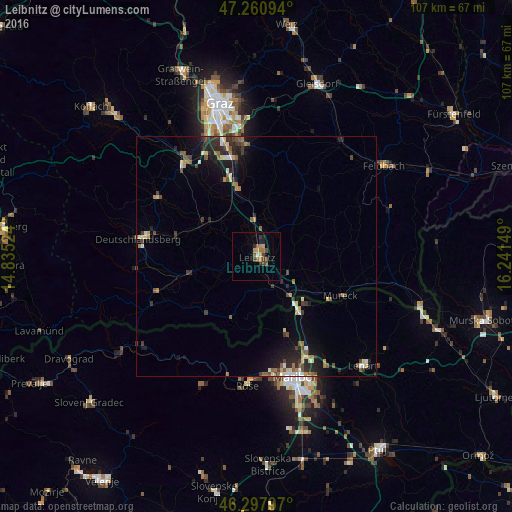
Analysis of Leibnitz night lights 2016
Square area 10x10 km:
 0.3%
0.3%90-99
0.3%80-89
0.3%70-79
2.53%60-69
2.08%50-59
1.93%40-49
3.27%30-39
1.79%20-29
1.64%10-19
0.74%0-9
85.12%Square area 50x50 km:
0.28%90-99
0.51%80-89
0.38%70-79
0.47%60-69
0.62%50-59
0.75%40-49
0.78%30-39
0.8%20-29
1.47%10-19
2.8%0-9
91.15%Clear (daylight) street map image can be seen on geolist.org.
Map coordinates:
47° 15' 39.4" North, 14° 50' 6.9" East
46° 46' 53.8" North, 15° 32' 18.1" East
46° 17' 52.7" North, 16° 14' 29.4" East
Some cities around Leibnitz sort by population:
• Maribor, SI
26.5 km =16.5 mi,  161°
161°
• Deutschlandsberg
24.4 km =15.2 mi,  278°
278°
• Seiersberg
26.5 km =16.5 mi,  336°
336°
• Kalsdorf bei Graz
20.9 km =13 mi,  347°
347°
• Šentilj v Slov. Goricah, SI
13.9 km =8.6 mi,  143°
143°
• Selnica ob Dravi, SI
26 km =16.2 mi,  187°
187°
• Pesnica pri Mariboru, SI
22.1 km =13.7 mi,  151°
151°
• Zgornja Kungota, SI
16.9 km =10.5 mi, 159°
2772753 (p: 8,533)
Sources (retrieved 2019-11-25):
» Earth at Night: Flat Maps 2012, 2016