Innere Stadt night lights from space
Night Light of Innere Stadt (Vienna) from space (Austria) Src. Average luminocity for 10x10km area is 98.1443% and for 50x50km: 26.1958%.
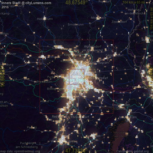
Analysis of Innere Stadt night lights 2016
Square area 10x10 km:
 66.37%
90-99
27.53%80-89
3.57%70-79
2.23%60-69
0.3%50-59
0%40-49
0%30-39
0%20-29
0%10-19
0%0-9
0%Square area 50x50 km:
6.52%90-99
5.47%80-89
2.17%70-79
2.8%60-69
3.18%50-59
2.72%40-49
2.5%30-39
3.49%20-29
6.67%10-19
10.77%0-9
53.69%Clear (daylight) street map image can be seen on geolist.org.
Map coordinates:
48° 40' 31.8" North, 15° 40' 5.6" East
48° 12' 32.6" North, 16° 22' 16.9" East
47° 44' 18" North, 17° 4' 28.1" East
Some cities around Innere Stadt sort by population:
• Vienna
0.1 km =0.1 mi,  139°
139°
• Favoriten
5.4 km =3.4 mi,  171°
171°
• Donaustadt
7.1 km =4.4 mi,  67°
67°
• Floridsdorf
5 km =3.1 mi,  24°
24°
• Ottakring
5.4 km =3.4 mi,  279°
279°
• Simmering
5.4 km =3.4 mi,  121°
121°
• Meidling
5.5 km =3.4 mi,  210°
210°
• Hietzing
6.1 km =3.8 mi,  245°
245°
2775260 (p: 16,450)
Sources (retrieved 2019-11-25):
» Earth at Night: Flat Maps 2012, 2016