Guntramsdorf night lights from space
Night Light of Guntramsdorf (Lower Austria) from space (Austria) Src. Average luminocity for 10x10km area is 50.0753% and for 50x50km: 24.6645%.
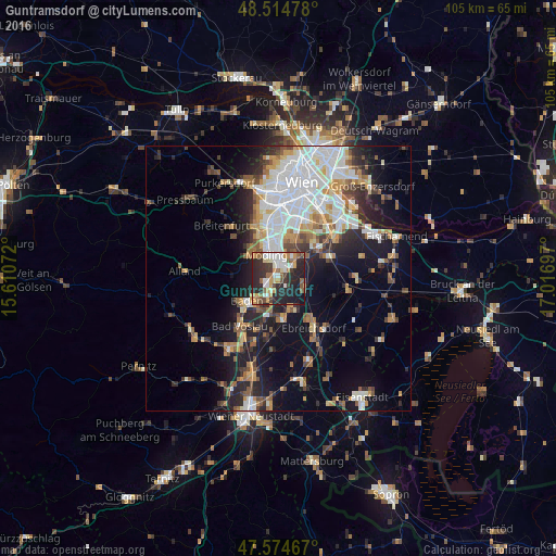
Analysis of Guntramsdorf night lights 2016
Square area 10x10 km:
 8.38%
8.38%90-99
9.94%80-89
3.13%70-79
10.23%60-69
5.68%50-59
7.39%40-49
4.4%30-39
9.8%20-29
29.83%10-19
10.8%0-9
0.43%Square area 50x50 km:
6.13%90-99
5.06%80-89
1.97%70-79
2.99%60-69
2.9%50-59
2.51%40-49
2.56%30-39
3.15%20-29
5.89%10-19
11.06%0-9
55.78%Clear (daylight) street map image can be seen on geolist.org.
Map coordinates:
48° 30' 53.2" North, 15° 36' 38.6" East
48° 2' 48.7" North, 16° 18' 49.8" East
47° 34' 28.8" North, 17° 1' 1.1" East
Some cities around Guntramsdorf sort by population:
• Baden
7.6 km =4.7 mi,  232°
232°
• Mödling
4.7 km =2.9 mi,  337°
337°
• Brunn am Gebirge
7 km =4.3 mi, 342°
• Wiener Neudorf
4 km =2.5 mi,  0°
0°
• Neu-Guntramsdorf
1.9 km =1.2 mi, 4°
• Maria Enzersdorf
6.3 km =3.9 mi, 339°
• Vösendorf
8.5 km =5.3 mi,  13°
13°
• Traiskirchen
3.9 km =2.4 mi,  203°
203°
2777250 (p: 9,179)
Sources (retrieved 2019-11-25):
» Earth at Night: Flat Maps 2012, 2016