Wiener Neudorf night lights from space
Night Light of Wiener Neudorf (Lower Austria) from space (Austria) Src. Average luminocity for 10x10km area is 63.247% and for 50x50km: 25.2744%.
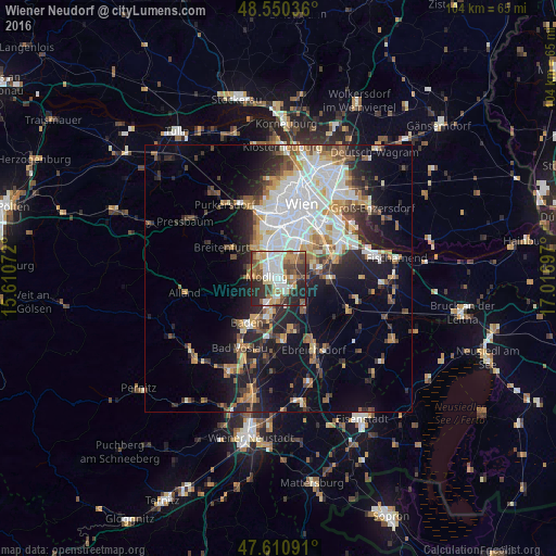
Analysis of Wiener Neudorf night lights 2016
Square area 10x10 km:
 15.18%
90-99
14.73%80-89
4.46%70-79
9.08%60-69
10.86%50-59
8.93%40-49
7.29%30-39
11.16%20-29
16.07%10-19
2.23%0-9
0%Square area 50x50 km:
6.25%90-99
5.08%80-89
2.11%70-79
2.91%60-69
3.21%50-59
2.8%40-49
2.57%30-39
3.28%20-29
5.86%10-19
10.94%0-9
55.01%Clear (daylight) street map image can be seen on geolist.org.
Map coordinates:
48° 33' 1.3" North, 15° 36' 38.6" East
48° 4' 58" North, 16° 18' 49.8" East
47° 36' 39.3" North, 17° 1' 1.1" East
Some cities around Wiener Neudorf sort by population:
• Mödling
1.9 km =1.2 mi,  281°
281°
• Perchtoldsdorf
5.4 km =3.4 mi,  318°
318°
• Brunn am Gebirge
3.5 km =2.2 mi, 321°
• Guntramsdorf
4 km =2.5 mi,  180°
180°
• Neu-Guntramsdorf
2.1 km =1.3 mi, 176°
• Maria Enzersdorf
3 km =1.9 mi,  310°
310°
• Vösendorf
4.7 km =2.9 mi,  24°
24°
• Leopoldsdorf
6.8 km =4.2 mi,  57°
57°
2761354 (p: 9,405)
Sources (retrieved 2019-11-25):
» Earth at Night: Flat Maps 2012, 2016