Firmat night lights from space
Night Light of Firmat (Santa Fe) from space (Argentina) Src. Average luminocity for 10x10km area is 14.3007% and for 50x50km: 1.4868%.
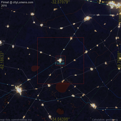
Analysis of Firmat night lights 2016
Square area 10x10 km:
 2.8%
2.8%90-99
1.4%80-89
2.45%70-79
2.62%60-69
1.92%50-59
0.7%40-49
0.7%30-39
1.4%20-29
0%10-19
1.75%0-9
84.27%Square area 50x50 km:
0.14%90-99
0.09%80-89
0.39%70-79
0.33%60-69
0.26%50-59
0.19%40-49
0.09%30-39
0.15%20-29
0.08%10-19
0.11%0-9
98.18%Clear (daylight) street map image can be seen on geolist.org.
Map coordinates:
32° 52' 14.8" South, 62° 11' 10.8" West
33° 27' 33.7" South, 61° 28' 59.5" West
34° 2' 38.3" South, 60° 46' 48.3" West
Some cities around Firmat sort by population:
• Venado Tuerto
55.1 km =34.2 mi,  234°
234°
• Cañada de Gómez
72 km =44.7 mi,  6°
6°
• Casilda
54.7 km =34 mi,  32°
32°
• Carcarañá
73.7 km =45.8 mi,  24°
24°
• Corral de Bustos
68.1 km =42.3 mi,  286°
286°
• Villa Cañás
61.8 km =38.4 mi,  190°
190°
• Cruz Alta
58.5 km =36.4 mi,  328°
328°
• Chañar Ladeado
53.6 km =33.3 mi, 286°
3855554 (p: 18,294)
Sources (retrieved 2019-11-25):
» Earth at Night: Flat Maps 2012, 2016