Concepción de la Sierra night lights from space
Night Light of Concepción de la Sierra (Misiones) from space (Argentina) Src. Average luminocity for 10x10km area is 4.4867% and for 50x50km: 1.3634%.
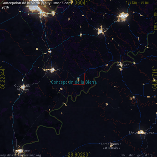
Analysis of Concepción de la Sierra night lights 2016
Square area 10x10 km:
 0%
0%90-99
0%80-89
0.76%70-79
1.89%60-69
1.14%50-59
0.57%40-49
0.19%30-39
1.52%20-29
0%10-19
0.76%0-9
93.18%Square area 50x50 km:
0.2%90-99
0.17%80-89
0.11%70-79
0.25%60-69
0.14%50-59
0.11%40-49
0.19%30-39
0.43%20-29
0.17%10-19
0.59%0-9
97.64%Clear (daylight) street map image can be seen on geolist.org.
Map coordinates:
27° 21' 37.5" South, 56° 13' 24.4" West
27° 58' 59.2" South, 55° 31' 13.1" West
28° 36' 8" South, 54° 49' 1.9" West
Some cities around Concepción de la Sierra sort by population:
• Oberá
67.8 km =42.1 mi,  35°
35°
• São Luiz Gonzaga, BR
72.4 km =45 mi,  130°
130°
• Garupá
63.5 km =39.5 mi,  331°
331°
• Gobernador Virasora
50.9 km =31.6 mi,  261°
261°
• Candelaria
62.3 km =38.7 mi,  339°
339°
• San José
35 km =21.7 mi,  312°
312°
• Panambí
66.1 km =41.1 mi,  64°
64°
• Cerro Azul
39 km =24.2 mi,  3°
3°
3435266 (p: 7,398)
Sources (retrieved 2019-11-25):
» Earth at Night: Flat Maps 2012, 2016