Llazicë night lights from space
Night Light of Llazicë (Prizren) from space (Kosovo) Src. Average luminocity for 10x10km area is 0.6476% and for 50x50km: 1.729%.
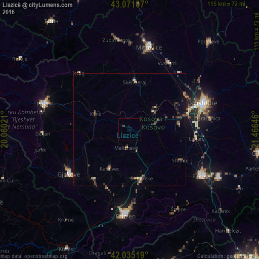
Analysis of Llazicë night lights 2016
Square area 10x10 km:
 0%
0%90-99
0%80-89
0%70-79
0%60-69
0%50-59
0%40-49
0.32%30-39
0.95%20-29
0%10-19
0.63%0-9
98.1%Square area 50x50 km:
0.02%90-99
0.16%80-89
0.14%70-79
0.16%60-69
0.34%50-59
0.29%40-49
0.38%30-39
0.65%20-29
0.48%10-19
0.53%0-9
96.85%Clear (daylight) street map image can be seen on geolist.org.
Map coordinates:
43° 4' 15.9" North, 20° 3' 36.8" East
42° 33' 19" North, 20° 45' 48" East
42° 2' 6.7" North, 21° 27' 59.3" East
Some cities around Llazicë sort by population:
• Suva Reka
22.4 km =13.9 mi,  166°
166°
• Glogovac
13.4 km =8.3 mi,  52°
52°
• Shtime
26.4 km =16.4 mi,  120°
120°
• Orahovac
19.5 km =12.1 mi,  207°
207°
• Obiliq
29.1 km =18.1 mi,  59°
59°
• Klina
16.9 km =10.5 mi,  295°
295°
• Mamuša
25.1 km =15.6 mi,  186°
186°
• Srbica
21.4 km =13.3 mi,  5°
5°
788470 (p: 19,863)
Sources (retrieved 2019-11-25):
» Earth at Night: Flat Maps 2012, 2016