Woodstock night lights from space
Night Light of Woodstock (Virginia) from space (United States) Src. Average luminocity for 10x10km area is 10.4082% and for 50x50km: 2.5758%.
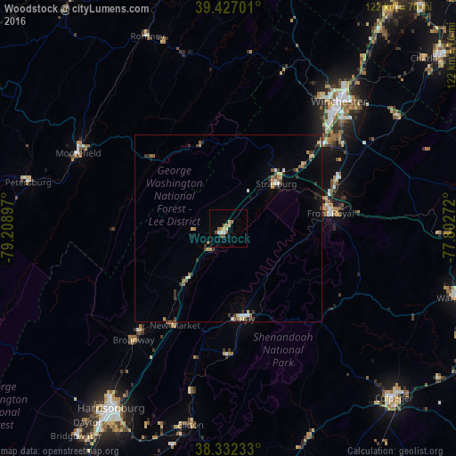
Analysis of Woodstock night lights 2016
Square area 10x10 km:
 1.02%
1.02%90-99
1.02%80-89
2.72%70-79
1.02%60-69
0.51%50-59
3.23%40-49
1.19%30-39
0.17%20-29
0%10-19
0.51%0-9
88.61%Square area 50x50 km:
0.17%90-99
0.24%80-89
0.51%70-79
0.25%60-69
0.29%50-59
0.44%40-49
0.27%30-39
0.66%20-29
0.27%10-19
0.74%0-9
96.17%Clear (daylight) street map image can be seen on geolist.org.
Map coordinates:
39° 25' 37.2" North, 79° 12' 32.3" West
38° 52' 54.4" North, 78° 30' 21" West
38° 19' 56.4" North, 77° 48' 9.8" West
Some cities around Woodstock sort by population:
• Harrisonburg
57.5 km =35.7 mi,  213°
213°
• Winchester
44.9 km =27.9 mi,  41°
41°
• Culpeper
63.4 km =39.4 mi,  135°
135°
• Front Royal
27.2 km =16.9 mi,  81°
81°
• Warrenton
64.4 km =40 mi,  106°
106°
• New Baltimore
68.5 km =42.6 mi,  100°
100°
• Strasburg
17.4 km =10.8 mi,  46°
46°
• Bridgewater
69 km =42.9 mi,  216°
216°
4794641 (p: 5,248)
Sources (retrieved 2019-11-25):
» Earth at Night: Flat Maps 2012, 2016