Winston night lights from space
Night Light of Winston (Oregon) from space (United States) Src. Average luminocity for 10x10km area is 9.3045% and for 50x50km: 2.1923%.
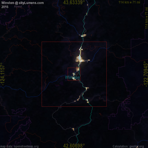
Analysis of Winston night lights 2016
Square area 10x10 km:
 0.3%
0.3%90-99
0.3%80-89
0.61%70-79
1.21%60-69
3.03%50-59
1.82%40-49
2.73%30-39
1.52%20-29
2.27%10-19
2.42%0-9
83.79%Square area 50x50 km:
0.21%90-99
0.23%80-89
0.16%70-79
0.3%60-69
0.39%50-59
0.27%40-49
0.43%30-39
0.34%20-29
0.32%10-19
2.01%0-9
95.33%Clear (daylight) street map image can be seen on geolist.org.
Map coordinates:
43° 38' 0.2" North, 124° 6' 56.5" West
43° 7' 20.4" North, 123° 24' 45.3" West
42° 36' 25.1" North, 122° 42' 34" West
Some cities around Winston sort by population:
• Grants Pass
76.2 km =47.3 mi,  174°
174°
• Roseburg
11.9 km =7.4 mi,  28°
28°
• Coos Bay
70.7 km =43.9 mi,  292°
292°
• Cottage Grove
80.3 km =49.9 mi,  20°
20°
• North Bend
72.9 km =45.3 mi,  295°
295°
• Sutherlin
30.9 km =19.2 mi, 15°
• Green
5.6 km =3.5 mi,  40°
40°
• Roseburg North
18.1 km =11.2 mi, 29°
5761481 (p: 5,393)
Sources (retrieved 2019-11-25):
» Earth at Night: Flat Maps 2012, 2016