Williamsburg night lights from space
Night Light of Williamsburg (Virginia) from space (United States) Src. Average luminocity for 10x10km area is 59.8793% and for 50x50km: 17.7708%.
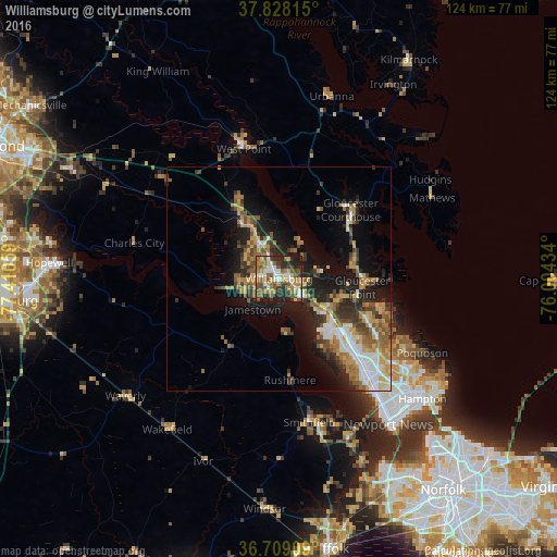
Analysis of Williamsburg night lights 2016
Square area 10x10 km:
 9.01%
9.01%90-99
9.52%80-89
10.03%70-79
6.29%60-69
12.76%50-59
16.5%40-49
8.16%30-39
11.22%20-29
14.29%10-19
2.21%0-9
0%Square area 50x50 km:
2.46%90-99
2.36%80-89
2.28%70-79
2.5%60-69
3.33%50-59
3.08%40-49
2.37%30-39
3.35%20-29
4.41%10-19
8.92%0-9
64.96%Clear (daylight) street map image can be seen on geolist.org.
Map coordinates:
37° 49' 41.3" North, 77° 24' 38.1" West
37° 16' 14.5" North, 76° 42' 26.9" West
36° 42' 32.7" North, 76° 0' 15.6" West
Some cities around Williamsburg sort by population:
• Newport News
29.6 km =18.4 mi,  134°
134°
• East Hampton
42.2 km =26.2 mi, 127°
• Hampton
41.8 km =26 mi, 129°
• Portsmouth Heights
58.3 km =36.2 mi,  148°
148°
• Hopewell
51.4 km =31.9 mi,  274°
274°
• Poquoson
36 km =22.4 mi,  117°
117°
• Gloucester Point
18.7 km =11.6 mi,  95°
95°
• Smithfield
32.8 km =20.4 mi,  168°
168°
4793846 (p: 15,052)
Sources (retrieved 2019-11-25):
» Earth at Night: Flat Maps 2012, 2016