Gloucester Point night lights from space
Night Light of Gloucester Point (Virginia) from space (United States) Src. Average luminocity for 10x10km area is 30.7551% and for 50x50km: 21.1641%.
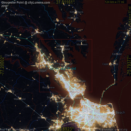
Analysis of Gloucester Point night lights 2016
Square area 10x10 km:
 0.34%
0.34%90-99
1.53%80-89
4.25%70-79
6.12%60-69
7.31%50-59
3.91%40-49
3.06%30-39
6.29%20-29
19.39%10-19
37.24%0-9
10.54%Square area 50x50 km:
3.62%90-99
3.49%80-89
2.71%70-79
2.95%60-69
3.64%50-59
3.27%40-49
2.43%30-39
3.47%20-29
4.86%10-19
8.99%0-9
60.56%Clear (daylight) street map image can be seen on geolist.org.
Map coordinates:
37° 48' 41.8" North, 77° 12' 0.1" West
37° 15' 14.5" North, 76° 29' 48.8" West
36° 41' 32.3" North, 75° 47' 37.6" West
Some cities around Gloucester Point sort by population:
• Norfolk
49 km =30.4 mi,  157°
157°
• Newport News
19.1 km =11.9 mi,  172°
172°
• East Hampton
28.2 km =17.5 mi,  148°
148°
• Hampton
28.3 km =17.6 mi, 151°
• Portsmouth Heights
49.5 km =30.8 mi, 166°
• Williamsburg
18.7 km =11.6 mi,  275°
275°
• Poquoson
19.8 km =12.3 mi,  137°
137°
• Smithfield
32.5 km =20.2 mi,  201°
201°
4761171 (p: 9,402)
Sources (retrieved 2019-11-25):
» Earth at Night: Flat Maps 2012, 2016