Poquoson night lights from space
Night Light of Poquoson (Virginia) from space (United States) Src. Average luminocity for 10x10km area is 39.1003% and for 50x50km: 27.4353%.
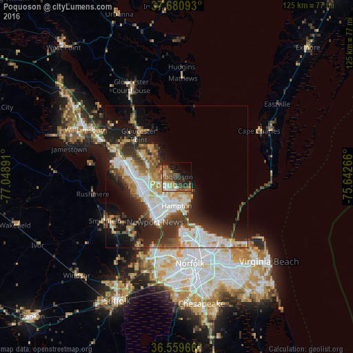
Analysis of Poquoson night lights 2016
Square area 10x10 km:
 4.76%
4.76%90-99
3.91%80-89
5.1%70-79
4.76%60-69
7.99%50-59
10.03%40-49
9.18%30-39
7.48%20-29
10.37%10-19
16.16%0-9
20.24%Square area 50x50 km:
5.97%90-99
5.73%80-89
2.57%70-79
3.29%60-69
3.53%50-59
3.31%40-49
3.33%30-39
5.04%20-29
7.5%10-19
11.18%0-9
48.54%Clear (daylight) street map image can be seen on geolist.org.
Map coordinates:
37° 40' 51.3" North, 77° 2' 56.1" West
37° 7' 20.5" North, 76° 20' 44.8" West
36° 33' 34.8" North, 75° 38' 33.6" West
Some cities around Poquoson sort by population:
• Norfolk
31.1 km =19.3 mi,  170°
170°
• Newport News
11.8 km =7.3 mi,  248°
248°
• East Hampton
9.5 km =5.9 mi, 172°
• Hampton
10.3 km =6.4 mi,  179°
179°
• Portsmouth Heights
33.6 km =20.9 mi, 183°
• Portsmouth
32.2 km =20 mi, 172°
• Gloucester Point
19.8 km =12.3 mi,  317°
317°
• Smithfield
29.7 km =18.5 mi,  238°
238°
4779923 (p: 12,059)
Sources (retrieved 2019-11-25):
» Earth at Night: Flat Maps 2012, 2016