Whitemarsh Island night lights from space
Night Light of Whitemarsh Island (Georgia) from space (United States) Src. Average luminocity for 10x10km area is 57.4038% and for 50x50km: 24.8464%.
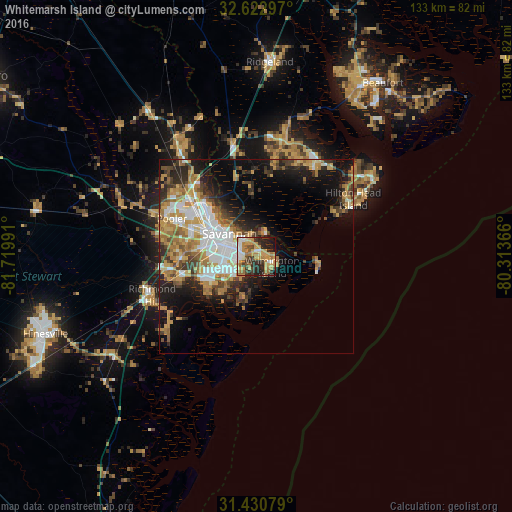
Analysis of Whitemarsh Island night lights 2016
Square area 10x10 km:
 6.64%
6.64%90-99
8.57%80-89
8.57%70-79
19.58%60-69
11.71%50-59
4.37%40-49
4.02%30-39
10.84%20-29
15.73%10-19
9.79%0-9
0.17%Square area 50x50 km:
4.33%90-99
4.23%80-89
2.76%70-79
4.93%60-69
4.84%50-59
2%40-49
2.83%30-39
3.63%20-29
5.55%10-19
10.71%0-9
54.2%Clear (daylight) street map image can be seen on geolist.org.
Map coordinates:
32° 37' 22.7" North, 81° 43' 11.7" West
32° 1' 43.8" North, 81° 1' 0.4" West
31° 25' 50.8" North, 80° 18' 49.2" West
Some cities around Whitemarsh Island sort by population:
• Savannah
9.9 km =6.2 mi,  307°
307°
• Pooler
23.7 km =14.7 mi,  293°
293°
• Bluffton
27.4 km =17 mi,  32°
32°
• Wilmington Island
4.9 km =3 mi,  124°
124°
• Georgetown
20.5 km =12.7 mi,  255°
255°
• Garden City
16.1 km =10 mi, 306°
• Skidaway Island
10.8 km =6.7 mi,  195°
195°
• Port Wentworth
19.2 km =11.9 mi, 314°
4230760 (p: 6,792)
Sources (retrieved 2019-11-25):
» Earth at Night: Flat Maps 2012, 2016