Tuscumbia night lights from space
Night Light of Tuscumbia (Alabama) from space (United States) Src. Average luminocity for 10x10km area is 63.5604% and for 50x50km: 13.2807%.
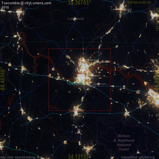
Analysis of Tuscumbia night lights 2016
Square area 10x10 km:
 15.02%
90-99
16.67%80-89
14.1%70-79
6.96%60-69
4.95%50-59
6.78%40-49
2.93%30-39
5.13%20-29
13.19%10-19
13.55%0-9
0.73%Square area 50x50 km:
1.52%90-99
1.72%80-89
2.45%70-79
1.67%60-69
1.91%50-59
1.78%40-49
1.83%30-39
2.29%20-29
3.69%10-19
7.34%0-9
73.79%Clear (daylight) street map image can be seen on geolist.org.
Map coordinates:
35° 18' 25.3" North, 88° 24' 20.4" West
34° 43' 52.3" North, 87° 42' 9.1" West
34° 9' 4.8" North, 86° 59' 57.9" West
Some cities around Tuscumbia sort by population:
• Florence
8 km =5 mi,  16°
16°
• East Florence
10 km =6.2 mi,  29°
29°
• Athens
67.2 km =41.8 mi,  83°
83°
• Muscle Shoals
3.5 km =2.2 mi,  64°
64°
• Lawrenceburg
66 km =41 mi, 30°
• Russellville
24.9 km =15.5 mi,  185°
185°
• Sheffield
3.8 km =2.4 mi,  5°
5°
• Danville
66.4 km =41.3 mi,  122°
122°
4094484 (p: 8,474)
Sources (retrieved 2019-11-25):
» Earth at Night: Flat Maps 2012, 2016