Toccoa night lights from space
Night Light of Toccoa (Georgia) from space (United States) Src. Average luminocity for 10x10km area is 38.8689% and for 50x50km: 9.0393%.
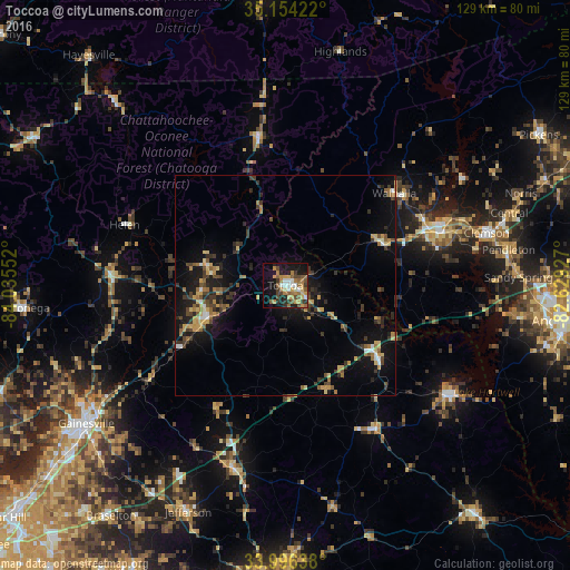
Analysis of Toccoa night lights 2016
Square area 10x10 km:
 4.55%
4.55%90-99
4.37%80-89
4.02%70-79
7.34%60-69
9.97%50-59
7.69%40-49
6.29%30-39
4.9%20-29
5.94%10-19
26.75%0-9
18.18%Square area 50x50 km:
0.48%90-99
0.6%80-89
1.24%70-79
1.42%60-69
1.43%50-59
1.33%40-49
1.42%30-39
2.21%20-29
2.08%10-19
7.86%0-9
79.91%Clear (daylight) street map image can be seen on geolist.org.
Map coordinates:
35° 9' 15.2" North, 84° 2' 7.9" West
34° 34' 38.4" North, 83° 19' 56.6" West
33° 59' 47" North, 82° 37' 45.4" West
Some cities around Toccoa sort by population:
• Gainesville
54.8 km =34.1 mi,  235°
235°
• Clemson
46.8 km =29.1 mi,  75°
75°
• Jefferson
55.7 km =34.6 mi,  203°
203°
• Seneca
36.7 km =22.8 mi,  70°
70°
• Commerce
43.1 km =26.8 mi, 195°
• Centerville
57.8 km =35.9 mi,  94°
94°
• Dahlonega
60 km =37.3 mi,  265°
265°
• Central
53 km =32.9 mi, 72°
4226722 (p: 8,283)
Sources (retrieved 2019-11-25):
» Earth at Night: Flat Maps 2012, 2016