Silver Lake night lights from space
Night Light of Silver Lake (North Carolina) from space (United States) Src. Average luminocity for 10x10km area is 63.0366% and for 50x50km: 22.4919%.
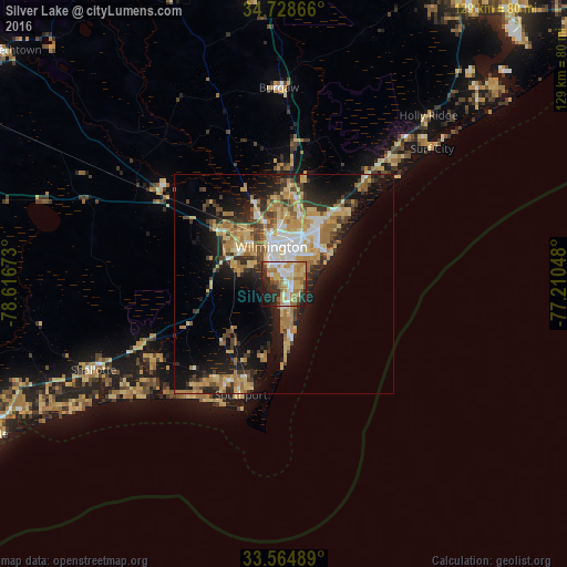
Analysis of Silver Lake night lights 2016
Square area 10x10 km:
 11.17%
90-99
10.26%80-89
15.75%70-79
11.54%60-69
14.65%50-59
4.95%40-49
2.2%30-39
7.14%20-29
14.47%10-19
7.33%0-9
0.55%Square area 50x50 km:
2.64%90-99
2.8%80-89
4.72%70-79
3.75%60-69
4.95%50-59
1.66%40-49
2.49%30-39
3.47%20-29
5.28%10-19
12.9%0-9
55.36%Clear (daylight) street map image can be seen on geolist.org.
Map coordinates:
34° 43' 43.2" North, 78° 37' 0.2" West
34° 8' 55.6" North, 77° 54' 49" West
33° 33' 53.6" North, 77° 12' 37.7" West
Some cities around Silver Lake sort by population:
• Wilmington
9 km =5.6 mi,  341°
341°
• Leland
17 km =10.6 mi,  314°
314°
• Masonboro
7 km =4.3 mi,  60°
60°
• Murraysville
17.4 km =10.8 mi,  20°
20°
• Myrtle Grove
3.3 km =2.1 mi,  118°
118°
• Kings Grant
13.5 km =8.4 mi, 19°
• Ogden
16.3 km =10.1 mi,  32°
32°
• Carolina Beach
12.8 km =8 mi,  171°
171°
4491715 (p: 5,598)
Sources (retrieved 2019-11-25):
» Earth at Night: Flat Maps 2012, 2016