Ogden night lights from space
Night Light of Ogden (North Carolina) from space (United States) Src. Average luminocity for 10x10km area is 69.8443% and for 50x50km: 21.187%.
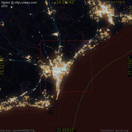
Analysis of Ogden night lights 2016
Square area 10x10 km:
 12.45%
90-99
15.02%80-89
13.19%70-79
15.02%60-69
18.68%50-59
3.3%40-49
4.76%30-39
7.69%20-29
8.06%10-19
1.83%0-9
0%Square area 50x50 km:
2.51%90-99
2.7%80-89
4.57%70-79
3.55%60-69
4.49%50-59
1.63%40-49
2.3%30-39
3.54%20-29
4.75%10-19
11.56%0-9
58.4%Clear (daylight) street map image can be seen on geolist.org.
Map coordinates:
34° 51' 5.1" North, 78° 31' 18.2" West
34° 16' 20.6" North, 77° 49' 6.9" West
33° 41' 21.7" North, 77° 6' 55.7" West
Some cities around Ogden sort by population:
• Wilmington
12.7 km =7.9 mi,  245°
245°
• Leland
20.9 km =13 mi,  265°
265°
• Masonboro
10.7 km =6.6 mi,  194°
194°
• Murraysville
3.7 km =2.3 mi,  314°
314°
• Myrtle Grove
16.4 km =10.2 mi,  200°
200°
• Kings Grant
4.3 km =2.7 mi,  255°
255°
• Carolina Beach
27.3 km =17 mi, 194°
• Silver Lake
16.3 km =10.1 mi,  212°
212°
4483174 (p: 6,766)
Sources (retrieved 2019-11-25):
» Earth at Night: Flat Maps 2012, 2016