Ridgefield night lights from space
Night Light of Ridgefield (Washington) from space (United States) Src. Average luminocity for 10x10km area is 12.3318% and for 50x50km: 14.9349%.
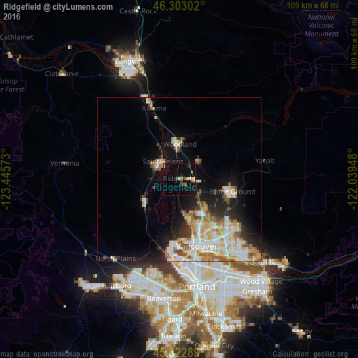
Analysis of Ridgefield night lights 2016
Square area 10x10 km:
 0.15%
0.15%90-99
0.45%80-89
2.38%70-79
2.38%60-69
1.64%50-59
1.49%40-49
0.89%30-39
1.79%20-29
2.23%10-19
7.59%0-9
79.02%Square area 50x50 km:
2.8%90-99
3.29%80-89
2.04%70-79
2.2%60-69
1.84%50-59
1.58%40-49
1.42%30-39
1.18%20-29
3.05%10-19
6.08%0-9
74.51%Clear (daylight) street map image can be seen on geolist.org.
Map coordinates:
46° 18' 10.9" North, 123° 26' 44.6" West
45° 48' 54.4" North, 122° 44' 33.4" West
45° 19' 22.4" North, 122° 2' 22.1" West
Some cities around Ridgefield sort by population:
• Salmon Creek
13.7 km =8.5 mi,  147°
147°
• Battle Ground
16.7 km =10.4 mi,  103°
103°
• Saint Helens
7.4 km =4.6 mi,  317°
317°
• Mount Vista
12.4 km =7.7 mi,  136°
136°
• Felida
12.1 km =7.5 mi,  166°
166°
• Scappoose
12.5 km =7.8 mi,  237°
237°
• Lake Shore
14.4 km =8.9 mi,  163°
163°
• Woodland
9.9 km =6.2 mi,  359°
359°
5808311 (p: 6,455)
Sources (retrieved 2019-11-25):
» Earth at Night: Flat Maps 2012, 2016