Pine Bluff night lights from space
Night Light of Pine Bluff (Arkansas) from space (United States) Src. Average luminocity for 10x10km area is 69.0641% and for 50x50km: 8.3912%.
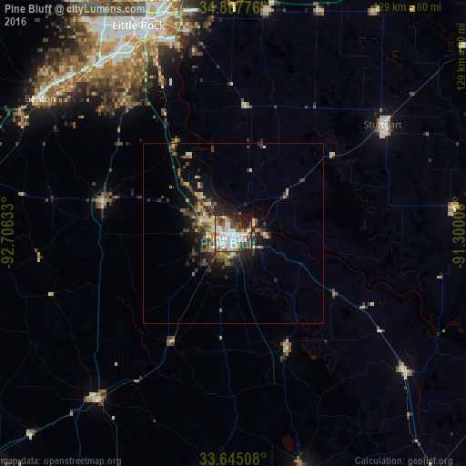

Analysis of Pine Bluff night lights 2016
Square area 10x10 km:
 20.15%
90-99
22.53%80-89
5.68%70-79
4.76%60-69
7.69%50-59
5.49%40-49
11.36%30-39
6.59%20-29
11.72%10-19
4.03%0-9
0%Square area 50x50 km:
1.01%90-99
1.35%80-89
0.88%70-79
0.72%60-69
1.32%50-59
1.23%40-49
1.39%30-39
2.29%20-29
2.47%10-19
4.87%0-9
82.49%Clear (daylight) street map image can be seen on geolist.org.
Map coordinates:
34° 48' 27.9" North, 92° 42' 22.8" West
34° 13' 42.3" North, 92° 0' 11.5" West
33° 38' 42.3" North, 91° 18' 0.3" West
Some cities around Pine Bluff sort by population:
• Little Rock
63.3 km =39.3 mi,  335°
335°
• North Little Rock
64.8 km =40.3 mi, 338°
• Benton
65.3 km =40.6 mi,  304°
304°
• Sherwood
68.3 km =42.4 mi, 342°
• Bryant
60.5 km =37.6 mi,  312°
312°
• Stuttgart
51.2 km =31.8 mi,  53°
53°
• East End
47.4 km =29.5 mi,  319°
319°
• White Hall
9.5 km =5.9 mi, 302°
4126226 (p: 44,772)
Sources (retrieved 2019-11-25):
» Earth at Night: Flat Maps 2012, 2016