Paulsboro night lights from space
Night Light of Paulsboro (New Jersey) from space (United States) Src. Average luminocity for 10x10km area is 74.9847% and for 50x50km: 66.5553%.
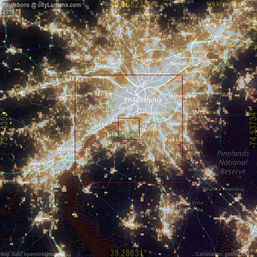
Analysis of Paulsboro night lights 2016
Square area 10x10 km:
 14.8%
14.8%90-99
14.12%80-89
9.18%70-79
18.88%60-69
19.9%50-59
16.33%40-49
4.08%30-39
2.72%20-29
0%10-19
0%0-9
0%Square area 50x50 km:
20.33%90-99
14.14%80-89
8.74%70-79
10.85%60-69
10.13%50-59
7.67%40-49
6.15%30-39
4.85%20-29
3.21%10-19
5.63%0-9
8.3%Clear (daylight) street map image can be seen on geolist.org.
Map coordinates:
40° 22' 5.6" North, 75° 56' 36.9" West
39° 49' 49.4" North, 75° 14' 25.7" West
39° 17' 17.9" North, 74° 32' 14.4" West
Some cities around Paulsboro sort by population:
• Woodbury
7.5 km =4.7 mi,  83°
83°
• Woodlyn
9.5 km =5.9 mi,  299°
299°
• Glenolden
8.8 km =5.5 mi,  331°
331°
• Ridley Park
9.1 km =5.7 mi,  308°
308°
• Folcroft
7.7 km =4.8 mi, 331°
• Prospect Park
8.6 km =5.3 mi,  317°
317°
• Norwood
8.5 km =5.3 mi, 323°
• Sharon Hill
8.9 km =5.5 mi,  342°
342°
4503516 (p: 5,989)
Sources (retrieved 2019-11-25):
» Earth at Night: Flat Maps 2012, 2016