Woodbury night lights from space
Night Light of Woodbury (New Jersey) from space (United States) Src. Average luminocity for 10x10km area is 83.4779% and for 50x50km: 67.517%.
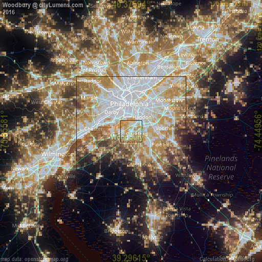
Analysis of Woodbury night lights 2016
Square area 10x10 km:
 16.84%
90-99
21.6%80-89
16.5%70-79
27.21%60-69
15.82%50-59
2.04%40-49
0%30-39
0%20-29
0%10-19
0%0-9
0%Square area 50x50 km:
21.03%90-99
14.39%80-89
8.83%70-79
11.61%60-69
10.39%50-59
6.66%40-49
5.29%30-39
4.59%20-29
3.93%10-19
5.79%0-9
7.49%Clear (daylight) street map image can be seen on geolist.org.
Map coordinates:
40° 22' 33.4" North, 75° 51' 20.9" West
39° 50' 17.4" North, 75° 9' 9.6" West
39° 17' 46.1" North, 74° 26' 58.4" West
Some cities around Woodbury sort by population:
• Whitman
8.7 km =5.4 mi,  358°
358°
• Bellmawr
5.9 km =3.7 mi,  56°
56°
• Gloucester City
6.7 km =4.2 mi,  27°
27°
• Audubon
9 km =5.6 mi,  49°
49°
• Runnemede
7.4 km =4.6 mi,  77°
77°
• Haddon Heights
8.7 km =5.4 mi, 59°
• Barrington
8.8 km =5.5 mi,  70°
70°
• Paulsboro
7.5 km =4.7 mi,  263°
263°
4504915 (p: 10,020)
Sources (retrieved 2019-11-25):
» Earth at Night: Flat Maps 2012, 2016