Oak Island night lights from space
Night Light of Oak Island (North Carolina) from space (United States) Src. Average luminocity for 10x10km area is 25.021% and for 50x50km: 10.6443%.
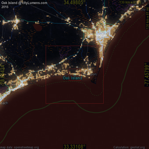
Analysis of Oak Island night lights 2016
Square area 10x10 km:
 0%
0%90-99
0%80-89
4.2%70-79
4.02%60-69
9.27%50-59
4.55%40-49
2.27%30-39
6.29%20-29
2.97%10-19
33.74%0-9
32.69%Square area 50x50 km:
0.41%90-99
0.41%80-89
2.08%70-79
1.73%60-69
2.83%50-59
0.92%40-49
1.39%30-39
1.87%20-29
3.03%10-19
11.52%0-9
73.81%Clear (daylight) street map image can be seen on geolist.org.
Map coordinates:
34° 29' 53" North, 78° 51' 51.3" West
33° 54' 59.6" North, 78° 9' 40" West
33° 19' 51.9" North, 77° 27' 28.8" West
Some cities around Oak Island sort by population:
• Wilmington
39.7 km =24.7 mi,  30°
30°
• Leland
39.3 km =24.4 mi,  15°
15°
• Masonboro
41.1 km =25.5 mi,  44°
44°
• Myrtle Grove
35.4 km =22 mi,  46°
46°
• Carolina Beach
28 km =17.4 mi,  61°
61°
• Boiling Spring Lakes
15.3 km =9.5 mi, 34°
• Long Beach
4.1 km =2.5 mi,  99°
99°
• Silver Lake
34.5 km =21.4 mi, 41°
4482916 (p: 7,507)
Sources (retrieved 2019-11-25):
» Earth at Night: Flat Maps 2012, 2016