Monument night lights from space
Night Light of Monument (Colorado) from space (United States) Src. Average luminocity for 10x10km area is 26.8068% and for 50x50km: 12.8663%.
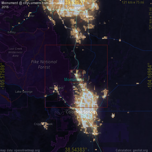
Analysis of Monument night lights 2016
Square area 10x10 km:
 1.46%
1.46%90-99
1.14%80-89
1.62%70-79
5.84%60-69
4.71%50-59
6.66%40-49
6.33%30-39
8.28%20-29
4.55%10-19
25.32%0-9
34.09%Square area 50x50 km:
1.89%90-99
2.16%80-89
1.82%70-79
2.29%60-69
1.85%50-59
1.87%40-49
1.33%30-39
2.61%20-29
2.59%10-19
5.35%0-9
76.25%Clear (daylight) street map image can be seen on geolist.org.
Map coordinates:
39° 38' 7" North, 105° 34' 33.2" West
39° 5' 30" North, 104° 52' 21.9" West
38° 32' 37.8" North, 104° 10' 10.7" West
Some cities around Monument sort by population:
• Colorado Springs
29 km =18 mi,  171°
171°
• Cimarron Hills
30 km =18.6 mi,  149°
149°
• Black Forest
17.2 km =10.7 mi,  120°
120°
• Woodmoor
2.4 km =1.5 mi,  63°
63°
• Woodland Park
19.3 km =12 mi,  235°
235°
• Air Force Academy
10.9 km =6.8 mi,  175°
175°
• Gleneagle
6.6 km =4.1 mi,  141°
141°
• Manitou Springs
26.1 km =16.2 mi,  188°
188°
5431740 (p: 6,420)
Sources (retrieved 2019-11-25):
» Earth at Night: Flat Maps 2012, 2016