Gleneagle night lights from space
Night Light of Gleneagle (Colorado) from space (United States) Src. Average luminocity for 10x10km area is 39.2971% and for 50x50km: 16.4081%.
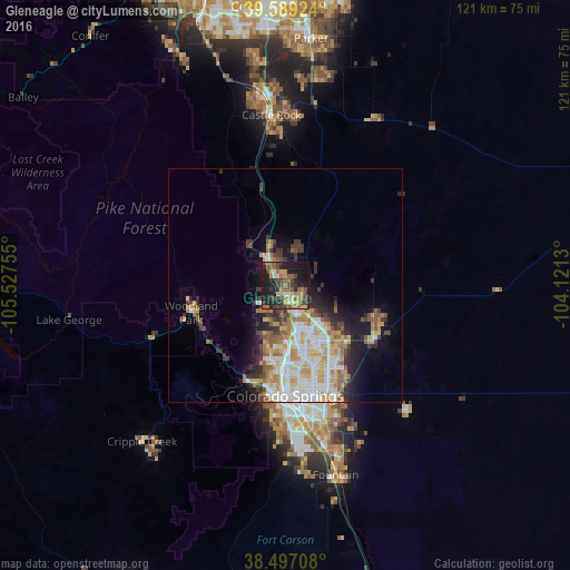
Analysis of Gleneagle night lights 2016
Square area 10x10 km:
 1.95%
1.95%90-99
1.46%80-89
4.06%70-79
5.68%60-69
11.36%50-59
10.06%40-49
9.09%30-39
10.71%20-29
14.61%10-19
27.6%0-9
3.41%Square area 50x50 km:
3.04%90-99
3.28%80-89
2.18%70-79
2.79%60-69
2.06%50-59
2.08%40-49
1.59%30-39
2.71%20-29
2.87%10-19
5.98%0-9
71.42%Clear (daylight) street map image can be seen on geolist.org.
Map coordinates:
39° 35' 21.3" North, 105° 31' 39.2" West
39° 2' 43" North, 104° 49' 27.9" West
38° 29' 49.5" North, 104° 7' 16.7" West
Some cities around Gleneagle sort by population:
• Colorado Springs
23.5 km =14.6 mi,  179°
179°
• Cimarron Hills
23.4 km =14.5 mi,  152°
152°
• Black Forest
11.3 km =7 mi,  108°
108°
• Woodmoor
6.5 km =4 mi,  342°
342°
• Woodland Park
20.9 km =13 mi,  254°
254°
• Air Force Academy
6.6 km =4.1 mi,  210°
210°
• Monument
6.6 km =4.1 mi,  321°
321°
• Manitou Springs
22.1 km =13.7 mi,  201°
201°
5423078 (p: 6,611)
Sources (retrieved 2019-11-25):
» Earth at Night: Flat Maps 2012, 2016