Medina night lights from space
Night Light of Medina (New York) from space (United States) Src. Average luminocity for 10x10km area is 7.9515% and for 50x50km: 4.608%.
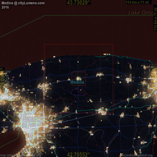
Analysis of Medina night lights 2016
Square area 10x10 km:
 0%
0%90-99
1.82%80-89
1.21%70-79
1.21%60-69
0.61%50-59
2.12%40-49
2.12%30-39
0%20-29
0%10-19
0%0-9
90.91%Square area 50x50 km:
0.23%90-99
0.59%80-89
0.69%70-79
0.53%60-69
0.51%50-59
0.83%40-49
1.06%30-39
0.79%20-29
1.03%10-19
2.98%0-9
90.77%Clear (daylight) street map image can be seen on geolist.org.
Map coordinates:
43° 43' 49" North, 79° 5' 24.4" West
43° 13' 12.2" North, 78° 23' 13.1" West
42° 42' 19.9" North, 77° 41' 1.9" West
Some cities around Medina sort by population:
• Lockport
25.2 km =15.7 mi,  257°
257°
• Batavia
29.5 km =18.3 mi,  146°
146°
• Brockport
36.3 km =22.6 mi,  91°
91°
• South Lockport
26.3 km =16.3 mi,  252°
252°
• Albion
15.9 km =9.9 mi,  79°
79°
• Hamlin
38.8 km =24.1 mi, 76°
• Harris Hill
36.9 km =22.9 mi,  219°
219°
• Williamsville
40.3 km =25 mi,  225°
225°
5126521 (p: 5,827)
Sources (retrieved 2019-11-25):
» Earth at Night: Flat Maps 2012, 2016