Lower Allen night lights from space
Night Light of Lower Allen (Pennsylvania) from space (United States) Src. Average luminocity for 10x10km area is 76.0049% and for 50x50km: 27.6899%.
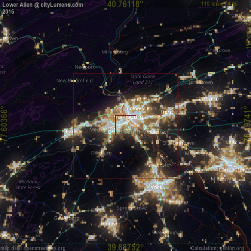
Analysis of Lower Allen night lights 2016
Square area 10x10 km:
 20.94%
90-99
20.29%80-89
8.44%70-79
11.53%60-69
12.99%50-59
7.47%40-49
9.74%30-39
5.19%20-29
3.41%10-19
0%0-9
0%Square area 50x50 km:
4.14%90-99
4.29%80-89
3.59%70-79
3.62%60-69
4.43%50-59
4.28%40-49
4.1%30-39
4.55%20-29
8.58%10-19
15.42%0-9
42.98%Clear (daylight) street map image can be seen on geolist.org.
Map coordinates:
40° 45' 40.2" North, 77° 36' 13.2" West
40° 13' 35.3" North, 76° 54' 1.9" West
39° 41' 15.1" North, 76° 11' 50.7" West
Some cities around Lower Allen sort by population:
• Harrisburg
5.4 km =3.4 mi,  14°
14°
• Colonial Park
11.3 km =7 mi,  43°
43°
• Progress
8.8 km =5.5 mi, 42°
• Mechanicsburg
9.3 km =5.8 mi,  261°
261°
• Camp Hill
2.2 km =1.4 mi,  311°
311°
• New Cumberland
1.5 km =0.9 mi,  64°
64°
• Enola
7.6 km =4.7 mi,  338°
338°
• Steelton
5.1 km =3.2 mi,  78°
78°
5199075 (p: 6,694)
Sources (retrieved 2019-11-25):
» Earth at Night: Flat Maps 2012, 2016