Linthicum night lights from space
Night Light of Linthicum (Maryland) from space (United States) Src. Average luminocity for 10x10km area is 95.3539% and for 50x50km: 68.4733%.
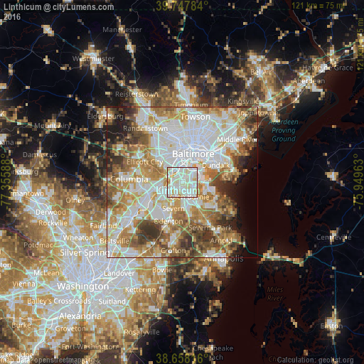
Analysis of Linthicum night lights 2016
Square area 10x10 km:
 38.47%
90-99
44.48%80-89
10.55%70-79
6.49%60-69
0%50-59
0%40-49
0%30-39
0%20-29
0%10-19
0%0-9
0%Square area 50x50 km:
20.7%90-99
16.7%80-89
8.21%70-79
9.82%60-69
9.52%50-59
8.88%40-49
6.02%30-39
5.71%20-29
3.86%10-19
4.16%0-9
6.42%Clear (daylight) street map image can be seen on geolist.org.
Map coordinates:
39° 44' 52.2" North, 77° 21' 21.2" West
39° 12' 18.4" North, 76° 39' 9.9" West
38° 39' 29.4" North, 75° 56' 58.7" West
Some cities around Linthicum sort by population:
• Glen Burnie
5.3 km =3.3 mi,  152°
152°
• Hanover
6.3 km =3.9 mi,  257°
257°
• Ferndale
2.7 km =1.7 mi,  156°
156°
• Elkridge
5.3 km =3.3 mi,  279°
279°
• Brooklyn Park
4.1 km =2.5 mi,  50°
50°
• Lansdowne
4.5 km =2.8 mi,  351°
351°
• Baltimore Highlands
3.4 km =2.1 mi,  24°
24°
• Pumphrey
1.9 km =1.2 mi,  44°
44°
4360713 (p: 10,324)
Sources (retrieved 2019-11-25):
» Earth at Night: Flat Maps 2012, 2016