Holtville night lights from space
Night Light of Holtville (California) from space (United States) Src. Average luminocity for 10x10km area is 5.4213% and for 50x50km: 16.0885%.
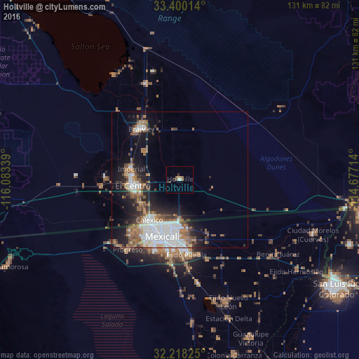
Analysis of Holtville night lights 2016
Square area 10x10 km:
 0%
0%90-99
1.05%80-89
0.35%70-79
0%60-69
1.4%50-59
2.45%40-49
0.52%30-39
1.75%20-29
0.87%10-19
0%0-9
91.61%Square area 50x50 km:
4.84%90-99
2.34%80-89
0.53%70-79
0.8%60-69
3.24%50-59
3%40-49
2.04%30-39
1.81%20-29
3.33%10-19
7.86%0-9
70.21%Clear (daylight) street map image can be seen on geolist.org.
Map coordinates:
33° 24' 0.5" North, 116° 5' 0.2" West
32° 48' 40.2" North, 115° 22' 48.9" West
32° 13' 5.7" North, 114° 40' 37.7" West
Some cities around Holtville sort by population:
• Mexicali, MX
21.5 km =13.4 mi,  198°
198°
• El Centro
17.2 km =10.7 mi,  262°
262°
• Calexico
18.4 km =11.4 mi,  217°
217°
• Santa Isabel, MX
27 km =16.8 mi, 222°
• Brawley
23.3 km =14.5 mi,  323°
323°
• Imperial
18.1 km =11.2 mi,  282°
282°
• Puebla, MX
27.3 km =17 mi,  174°
174°
• Progreso, MX
32 km =19.9 mi, 216°
5357598 (p: 6,404)
Sources (retrieved 2019-11-25):
» Earth at Night: Flat Maps 2012, 2016